
Mapa topográfico Grand River
Mapa interactivo
Haga clic en el mapa para ver la altitud.
Acerca de este mapa
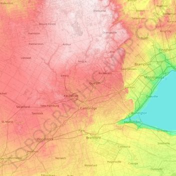
Nombre: Mapa topográfico Grand River, altitud, relieve.
Altitud media: 300 m
Altitud mínima: 70 m
Altitud máxima: 526 m
Otros mapas topográficos
Haga clic en un mapa para ver su topografía, su altitud y su relieve.
Vaughan
Canadá > Ontario > York Region
Vaughan, York Region, Golden Horseshoe, Ontario, Canadá
Altitud media: 220 m
Northern Bruce Peninsula
Canadá > Ontario > Northern Bruce Peninsula
Northern Bruce Peninsula, Bruce County, Southwestern Ontario, Ontario, Canadá
Altitud media: 183 m
Georgian Bay
Canadá > Ontario > Georgian Bay
Georgian Bay, District Municipality of Muskoka, Muskoka District, Ontario, Canadá
Altitud media: 192 m
Victoria Island
Victoria Island, (Old) Ottawa, Ottawa, Ontario, K1R 1C5, Canadá
Altitud media: 126 m
Windermere Lake
Canadá > Ontario > Unorganized South Nipissing
Windermere Lake, Unorganized South Nipissing, Nipissing District, Ontario, Canadá
Altitud media: 355 m
Lake Simcoe
Canadá > Ontario > Oro-Medonte
Lake Simcoe, Oro-Medonte, Simcoe County, Central Ontario, Ontario, L3Y 7C1, Canadá
Altitud media: 247 m
Lago Nipigon
Canadá > Ontario > Unorganized Thunder Bay District
Lago Nipigon, Unorganized Thunder Bay District, Thunder Bay District, Northwestern Ontario, Ontario, Canadá
Altitud media: 307 m
Manitoulin Island
Canadá > Ontario > Northeastern Manitoulin and the Islands
Manitoulin Island, Northeastern Manitoulin and the Islands, Manitoulin District, Ontario, Canadá
Altitud media: 202 m