
Haz una donación
Mapa topográfico Larch Mountain
Haga clic en el mapa para ver la altitud.
Haz una donación
Acerca de este mapa
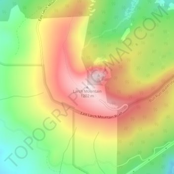
Nombre: Mapa topográfico Larch Mountain, altitud, relieve.
Lugar: Larch Mountain, Multnomah County, Oregon, United States (45.53090 -122.09041 45.53100 -122.09031)
Altitud media: 1,002 m
Altitud mínima: 800 m
Altitud máxima: 1,206 m
Haz una donación
Otros mapas topográficos
Haga clic en un mapa para ver su topografía, su altitud y su relieve.
Haz una donación
Forest Park
United States > Oregon > Multnomah County > Portland
Solidified lava from Grande Ronde members of the Columbia River Basalt Group underlie Forest Park. About 16 million years ago during the Middle Miocene, the Columbia River ran through a lowland south of its modern channel. Eruptions from linear vents in eastern Oregon and Washington flowed down this channel…
Altitud media: 91 m
Duck Lake Willamette River Greenway
United States > Oregon > Multnomah County > Scappoose
Altitud media: 52 m
Haz una donación
Haz una donación
Haz una donación
Haz una donación
Haz una donación