
Haz una donación
Mapa topográfico Tagaytay
Haga clic en el mapa para ver la altitud.
Haz una donación
Tagaytay
It is one of the country's most popular destinations for domestic tourism because of its scenery and cooler climate provided by its altitude. Tagaytay overlooks Taal Lake in Batangas and provides views of Taal Volcano Island in the middle of the lake through various vantage points situated in the city.
Haz una donación
Acerca de este mapa
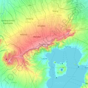
Nombre: Mapa topográfico Tagaytay, altitud, relieve.
Lugar: Tagaytay, Cavite, Calabarzon, 4120, Philippines (13.94314 120.77205 14.26314 121.09205)
Altitud media: 229 m
Altitud mínima: -3 m
Altitud máxima: 762 m
Haz una donación
Otros mapas topográficos
Haga clic en un mapa para ver su topografía, su altitud y su relieve.
Caballo Island
Philippines > Cavite > Cavite City
Caballo Island (which means "Horse Island" in Spanish) is a bluff, rocky island located at the entrance to Manila Bay in the Philippines. It is about 1.2 km (0.75 mi) long with the highest elevation at 381 feet high. Caballo, along with the larger Corregidor (2 km to the north), divides the entrance to the bay…
Altitud media: 0 m
Haz una donación
Haz una donación
Tagaytay Heights
Philippines > Cavite > Tagaytay > Kaybagal East > Tagaytay Heights
Altitud media: 612 m
Haz una donación
Carmona
The topography of Carmona is generally flat to strongly rolling or sloping, partly lowland and partly hill. Carmona is divided into four physiographical areas: the lowest lowland area, the lowland area, the central hilly area and the upland mountainous area.
Altitud media: 56 m
Haz una donación
Haz una donación
Haz una donación