
Gracias por apoyar a este sitio ❤️
Haz una donación
Haz una donación
Mapa topográfico Cabungahan
Haga clic en el mapa para ver la altitud.
Gracias por apoyar a este sitio ❤️
Haz una donación
Haz una donación
Acerca de este mapa
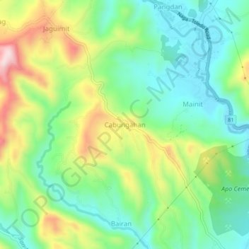
Nombre: Mapa topográfico Cabungahan, altitud, relieve.
Lugar: Cabungahan, Cebu, Central Visayas, 6037, Philippines (10.19364 123.70028 10.23364 123.74028)
Altitud media: 153 m
Altitud mínima: 12 m
Altitud máxima: 415 m
Gracias por apoyar a este sitio ❤️
Haz una donación
Haz una donación
Otros mapas topográficos
Haga clic en un mapa para ver su topografía, su altitud y su relieve.
Cordova
The surface of the town consists entirely of karstic limestone rock geologically associated with the Plio-Pleistocene Carcar Formation, dated to 2½–3 million years ago. The topography of Cordova is flat land, the highest point being only 10 metres (33 ft) above sea level.
Altitud media: 0 m
Gracias por apoyar a este sitio ❤️
Haz una donación
Haz una donación