
Gracias por apoyar a este sitio ❤️
Haz una donación
Haz una donación
Mapa topográfico Rome
Haga clic en el mapa para ver la altitud.
Gracias por apoyar a este sitio ❤️
Haz una donación
Haz una donación
Acerca de este mapa
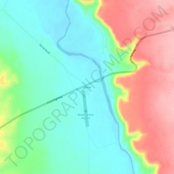
Nombre: Mapa topográfico Rome, altitud, relieve.
Lugar: Rome, Malheur County, Oregon, United States (42.81830 -117.64852 42.85830 -117.60852)
Altitud media: 1,075 m
Altitud mínima: 1,022 m
Altitud máxima: 1,161 m
Gracias por apoyar a este sitio ❤️
Haz una donación
Haz una donación
Otros mapas topográficos
Haga clic en un mapa para ver su topografía, su altitud y su relieve.
Vale
United States > Oregon > Malheur County
According to the United States Census Bureau, the city has a total area of 1.14 square miles (2.95 km2), all of it land. The city has an elevation of 2,244 feet (684 m) above sea level.
Altitud media: 710 m