
Haz una donación
Mapa topográfico Mount Hunter
Haga clic en el mapa para ver la altitud.
Haz una donación
Acerca de este mapa
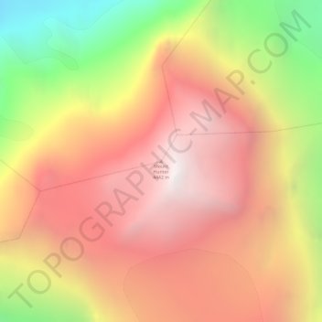
Nombre: Mapa topográfico Mount Hunter, altitud, relieve.
Altitud media: 3,593 m
Altitud mínima: 2,391 m
Altitud máxima: 4,432 m
Haz una donación
Otros mapas topográficos
Haga clic en un mapa para ver su topografía, su altitud y su relieve.
Skwentna
United States > Alaska > Matanuska-Susitna Borough
Hayes River is a weather station near Skwentna to the northeast, at an elevation of 1,000 feet (300 m). Hayes River also has a subarctic climate (Köppen Dfc) but has a lower seasonal temperature variation and receives substantially more snow.
Altitud media: 203 m
Haz una donación
Trapper Creek
United States > Alaska > Matanuska-Susitna Borough
Trapper Creek is a community located in Matanuska-Susitna Borough at latitude 62.317 and longitude -150.231, with an elevation of 351 ft (107 m). It is at mile 114.5 on the Parks Highway, just south of Denali State Park. Trapper Creek is found at the intersection of Petersville Road and is spread out along the…
Altitud media: 235 m
Haz una donación
Denali State Park
United States > Alaska > Matanuska-Susitna Borough
Denali State Park is in sight of Denali, the highest mountain peak in North America, with a summit elevation of 20,310 feet above sea level. Denali rises 18,000 feet from base to peak, making it the largest mountain situated entirely above sea level. To the east, the state park borders the Susitna River, which…
Altitud media: 702 m
Haz una donación
Haz una donación