
Haz una donación
Mapa topográfico Eden
Haga clic en el mapa para ver la altitud.
Haz una donación
Eden
Eden is a census-designated place in Weber County, Utah, United States. It is home to Powder Mountain ski resort. It lies between the North and Middle Fork of the Ogden River, north of Pineview Reservoir, in the Ogden Valley. The elevation is 4,941 feet (1,506 m). The population was 600 at the 2010 census. It has a post office with the ZIP code 84310. Eden is part of the Ogden–Clearfield, Utah Metropolitan Statistical Area, as well as the Ogden Valley census county division
Haz una donación
Acerca de este mapa
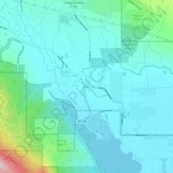
Nombre: Mapa topográfico Eden, altitud, relieve.
Lugar: Eden, Weber County, Utah, 84310, United States (41.28447 -111.84630 41.32447 -111.80630)
Altitud media: 1,562 m
Altitud mínima: 1,484 m
Altitud máxima: 1,964 m
Haz una donación
Otros mapas topográficos
Haga clic en un mapa para ver su topografía, su altitud y su relieve.
Ogden
United States > Utah > Weber County
According to the United States Census Bureau, the city has an area of 26.6 square miles (69.0 km2), all land. Elevations in the city range from about 4,300 to 5,000 feet (1,300 to 1,500 m) above sea level.
Altitud media: 1,498 m
Ogden
United States > Utah > Weber County
According to the United States Census Bureau, the city has an area of 26.6 square miles (69.0 km2), all land. Elevations in the city range from about 4,300 to 5,000 feet (1,300 to 1,500 m) above sea level.
Altitud media: 1,498 m
Haz una donación
Ogden
United States > Utah > Weber County
According to the United States Census Bureau, the city has an area of 26.6 square miles (69 km2), all land. Elevations in the city range from about 4,300 to 5,000 feet (1,300 to 1,500 m) above sea level.
Altitud media: 1,498 m
Haz una donación
Haz una donación
Haz una donación
Ogden
United States > Utah > Weber County
According to the United States Census Bureau, the city has an area of 26.6 square miles (69.0 km2), all land. Elevations in the city range from about 4,300 to 5,000 feet (1,300 to 1,500 m) above sea level.
Altitud media: 1,498 m
Haz una donación