
Haz una donación
Mapa topográfico Mansel Island
Haga clic en el mapa para ver la altitud.
Haz una donación
Mansel Island
Mansel Island (Inuktitut: Pujjunaq), a member of the Arctic Archipelago, is an uninhabited island in Qikiqtaaluk Region, Nunavut. It is located in Hudson Bay off Quebec's Ungava Peninsula. At 3,180 km2 (1,230 sq mi) in size, it is the 159th largest island in the world, and Canada's 28th largest island. Its topography features a gently undulating limestone lowland with elevations not exceeding 100 m.
Haz una donación
Acerca de este mapa
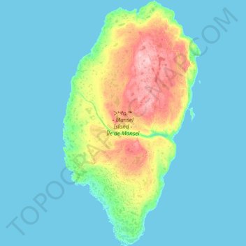
Nombre: Mapa topográfico Mansel Island, altitud, relieve.
Lugar: Mansel Island, Nunavut, Canada (61.57142 -80.27325 62.41569 -79.26067)
Altitud media: 17 m
Altitud mínima: -3 m
Altitud máxima: 126 m
Haz una donación
Otros mapas topográficos
Haga clic en un mapa para ver su topografía, su altitud y su relieve.
Arctic Bay
Canada > Nunavut > Qikiqtaaluk Region
Arctic Bay experiences a tundra climate (Köppen: ET) like most northern Canadian territories at low elevations, with long, very cold winters and short, cool to cold summers. July is the only month with an average low temperature above freezing. Its climate does not differ from the more severe subarctic…
Altitud media: 160 m
Haz una donación
Haz una donación