
Haz una donación
Mapa topográfico Aleosan
Haga clic en el mapa para ver la altitud.
Haz una donación
Acerca de este mapa
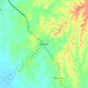
Nombre: Mapa topográfico Aleosan, altitud, relieve.
Lugar: Aleosan, North Cotabato, Soccsksargen, 9415, Philippines (7.11858 124.53740 7.19858 124.61740)
Altitud media: 44 m
Altitud mínima: 5 m
Altitud máxima: 125 m
Haz una donación
Otros mapas topográficos
Haga clic en un mapa para ver su topografía, su altitud y su relieve.
Kabacan
The landscape is characterized by almost regular landscape of flat terrain. The high mountains and rolling hills leaping close to the river plus the narrow plains have varied topographical features. Other features are moderately sloping and strongly sloping.
Altitud media: 95 m
Magpet
Rice production in Magpet is only 1.16% or 1,028 hectares of the total land area with another 1.50% or 1,115 hectares as potential area due to its land topography, which is mostly hilly or mountainous.
Altitud media: 597 m
Haz una donación