
Haz una donación
Mapa topográfico San Vicente
Haga clic en el mapa para ver la altitud.
Haz una donación
Acerca de este mapa
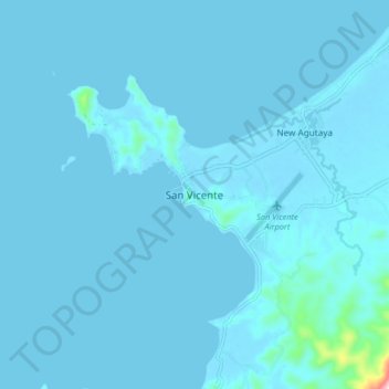
Nombre: Mapa topográfico San Vicente, altitud, relieve.
Lugar: San Vicente, Roxas, Palawan, Mimaropa, 5309, Philippines (10.48774 119.21694 10.56774 119.29694)
Altitud media: 8 m
Altitud mínima: -2 m
Altitud máxima: 272 m
Haz una donación
Otros mapas topográficos
Haga clic en un mapa para ver su topografía, su altitud y su relieve.
Haz una donación
Haz una donación
Haz una donación
Kalayaan
The islets that comprise the municipality are generally flat. The highest ground elevation is approximately two meters above sea level.
Altitud media: 0 m
Haz una donación
Haz una donación
Cagayancillo
There are neither mountain ranges nor forested areas in the municipality. A hilly portion in the north-eastern part of the main island has a slope of 3-82%. The other areas are flat with the highest elevation around 2 to 3 meters. The majority of the island has a sandy loam soil not enough to support a forest.…
Altitud media: 0 m