
Gracias por apoyar a este sitio ❤️
Haz una donación
Haz una donación
Mapa topográfico Bulu Hatu
Haga clic en el mapa para ver la altitud.
Gracias por apoyar a este sitio ❤️
Haz una donación
Haz una donación
Acerca de este mapa
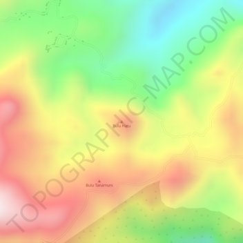
Nombre: Mapa topográfico Bulu Hatu, altitud, relieve.
Lugar: Bulu Hatu, South Sulawesi, Sulawesi, Indonesia (-5.05515 120.06495 -5.05505 120.06505)
Altitud media: 644 m
Altitud mínima: 349 m
Altitud máxima: 917 m
Gracias por apoyar a este sitio ❤️
Haz una donación
Haz una donación
Otros mapas topográficos
Haga clic en un mapa para ver su topografía, su altitud y su relieve.
Makassar
Makassar City is a city located near the coast that stretches along the western and northern corridors and is also known as the "Waterfront City" which contains several rivers such as the Tallo River, Jeneberang River, and Pampang River) all of which flow into the city. Makassar City is a stretch of lowland at…
Altitud media: 13 m