
Haz una donación
Mapa topográfico San Felipe
Haga clic en el mapa para ver la altitud.
Haz una donación
Acerca de este mapa
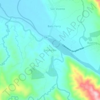
Nombre: Mapa topográfico San Felipe, altitud, relieve.
Lugar: San Felipe, Nueva Ecija, Central Luzon, Philippines (15.53282 121.20763 15.57282 121.24763)
Altitud media: 125 m
Altitud mínima: 73 m
Altitud máxima: 358 m
Haz una donación
Otros mapas topográficos
Haga clic en un mapa para ver su topografía, su altitud y su relieve.
Pampanga River
Its main tributaries are Peñaranda and the Coronel-Santor rivers on the eastern side of the basin and the Rio Chico River from the northwest side. The Angat River joins the Pampanga River at Calumpit, Bulacan via the Bagbag River. Mount Arayat (elevation: 1,026 metres (3,366 ft)) stands in the middle of the…
Altitud media: 190 m
Pantabangan Dam
Philippines > Nueva Ecija > Pantabangan > Fatima
The dam is a 107 m (351 ft) tall and 1,615 m (5,299 ft) long embankment-type with 12,000,000 cu yd (9,174,658 m3) of homogeneous earth-fill and an impervious core. The crest of the dam is 12 m (39 ft) wide while the widest part of its base is 535 m (1,755 ft). The dam's crest sits at an elevation of 232 m (761…
Altitud media: 210 m
Haz una donación
Haz una donación
Talavera
The municipality's terrain is relatively flat, with slope ranging from 0 to 3%. Due to the flat topography, the land is suited for agricultural, commercial or industrial development. It is bordered by Cabanatuan, Llanera, Muñoz, Aliaga, General Mamerto Natividad, Santo Domingo and San Jose.
Altitud media: 49 m