
Haz una donación
Mapa topográfico Nagoya
Haga clic en el mapa para ver la altitud.
Haz una donación
Acerca de este mapa
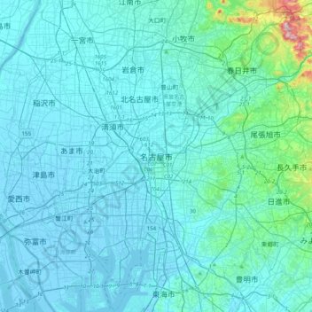
Nombre: Mapa topográfico Nagoya, altitud, relieve.
Lugar: Nagoya, Aichi Prefecture, 451-0031, Japan (35.02510 136.73984 35.34510 137.05984)
Altitud media: 31 m
Altitud mínima: -7 m
Altitud máxima: 413 m
Haz una donación
Otros mapas topográficos
Haga clic en un mapa para ver su topografía, su altitud y su relieve.
Tokyo
The mainland portion of Tokyo lies northwest of Tokyo Bay and measures about 90 km (56 mi) east to west and 25 km (16 mi) north to south. The average elevation in Tokyo is 40 m (131 ft). Chiba Prefecture borders it to the east, Yamanashi to the west, Kanagawa to the south, and Saitama to the north. Mainland…
Altitud media: 22 m
Kamakura
The Kamakura shogunate era is called by historians the Kamakura period and, although its end is clearly set (Siege of Kamakura (1333)), its beginning is not. Different historians put Kamakura's beginning at a different point in time within a range that goes from the establishment of Yoritomo's first military…
Altitud media: 33 m
Haz una donación
Hokkaido
As Japan's coldest region, Hokkaidō has relatively cool summers and icy/snowy winters. Most of the island falls in the humid continental climate zone with Köppen climate classification Dfb (hemiboreal) in most areas but Dfa (hot summer humid continental) in some inland lowlands. The average August…
Altitud media: 98 m
Haz una donación
Shinjuku
Naturally, most of Shinjuku is occupied by the Yodobashi Plateau, the most elevated portion of which extends through most of the Shinjuku Station area. The Kanda River runs through the Ochiai and Totsuka areas near sea level, but the Toshima Plateau also builds elevation in the northern extremities of Totsuka…
Altitud media: 35 m
Sendai
Sendai is located at lat. 38°16'05" north, long. 140°52'11" east. The city's area is 788.09 km2 (304.28 sq mi), and stretches from the Pacific Ocean to the Ōu Mountains, which are the east and west borders of Miyagi Prefecture. As a result, the city's geography is quite diverse. Eastern Sendai is a plains…
Altitud media: 185 m
Haz una donación
Sapporo
Sapporo is a city located in the southwest part of Ishikari Plain and the alluvial fan of the Toyohira River, a tributary stream of the Ishikari River. It is part of Ishikari Subprefecture. Roadways in the urban district are laid to make a grid plan. The western and southern parts of Sapporo are occupied by a…
Altitud media: 273 m
Kanagawa Prefecture
Topographically, the prefecture consists of three distinct areas. The mountainous western region features the Tanzawa Mountain Range and the volcano Mount Hakone. The hilly eastern region is characterized by the Tama Hills and Miura Peninsula. The central region, which surrounds the Tama Hills and Miura…
Altitud media: 170 m
Haz una donación
Yokohama
Yokohama has a total area of 437.38 km2 (168.87 sq mi) at an elevation of 5 metres (16 ft) above sea level. It is the capital of Kanagawa Prefecture, bordered to the east by Tokyo Bay and located in the middle of the Kantō plain. The city is surrounded by hills and the characteristic mountain system of the…
Altitud media: 23 m
Sapporo
Sapporo is a city located in the southwest part of Ishikari Plain and the alluvial fan of the Toyohira River, a tributary stream of the Ishikari River. It is part of Ishikari Subprefecture. Roadways in the urban district are laid to make a grid plan. The western and southern parts of Sapporo are occupied by a…
Altitud media: 273 m
Tokyo
The mainland portion of Tokyo lies northwest of Tokyo Bay and measures about 90 km (56 mi) east to west and 25 km (16 mi) north to south. The average elevation in Tokyo is 40 m (131 ft). Chiba Prefecture borders it to the east, Yamanashi to the west, Kanagawa to the south, and Saitama to the north. Mainland…
Altitud media: 22 m
Haz una donación
Haz una donación
Haz una donación
Hakone
Hakone is characterized by its rugged topography, featuring a mix of mountainous terrain, valleys, and volcanic landscapes. Nestled within the greater Fuji-Hakone-Izu National Park, Hakone's elevation varies dramatically, with peaks rising over 4,000 feet and low-lying areas near Lake Ashi, which sits at…
Altitud media: 722 m
Haz una donación
Nagano
Nagano (長野市, Nagano-shi, pronounced [nagaꜜno ɕi]) is the capital and largest city of Nagano Prefecture, located in the Nagano Basin (Zenkoji Daira) in the central Chūbu region of Japan. Nagano is categorized as a core city of Japan. Nagano City is the highest prefectural capital in Japan, with an…
Altitud media: 828 m
Sendai
Sendai is located at lat. 38°16'05" north, long. 140°52'11" east. The city's area is 788.09 km2 (304.28 sq mi), and stretches from the Pacific Ocean to the Ōu Mountains, which are the east and west borders of Miyagi Prefecture. As a result, the city's geography is quite diverse. Eastern Sendai is a plains…
Altitud media: 185 m
Haz una donación
Haz una donación
Haz una donación
Takayama
Takayama (高山市, Takayama-shi) is a city located in Gifu Prefecture, Japan. As of 1 January 2019, the city had an estimated population of 88,473 in 35,644 households, and a population density of 41 persons per km2. The total area of the city was 2,177.61 square kilometres (840.78 sq mi) making it the…
Altitud media: 1,157 m
Nagasaki
On the day of the nuclear strike (August 9, 1945) the population in Nagasaki was estimated to be 263,000, which consisted of 240,000 Japanese residents, 10,000 Korean residents, 2,500 conscripted Korean workers, 9,000 Japanese soldiers, 600 conscripted Chinese workers, and 400 Allied POWs. That day, the Boeing…
Altitud media: 44 m
Tokyo
The mainland portion of Tokyo lies northwest of Tokyo Bay and measures about 90 km (56 mi) east to west and 25 km (16 mi) north to south. The average elevation in Tokyo is 40 m (131 ft). Chiba Prefecture borders it to the east, Yamanashi to the west, Kanagawa to the south, and Saitama to the north. Mainland…
Altitud media: 22 m
Tsushima Island
Tsushima is the closest Japanese territory to the Korean Peninsula, lying approximately 50 km from Busan. On a clear day, the hills and mountains of the Korean peninsula are visible from the higher elevations on the two northern mountains. The nearest Japanese port, Iki, situated on Iki Island within the…
Altitud media: 16 m
Haz una donación
Haz una donación
Haz una donación
Haz una donación
Yakushima
The bedrock of the island is granite, and as such it hosts no active volcanoes. It has an area of approximately 504.5 square kilometres (194.8 sq mi). The island is roughly circular in shape, with a circumference of 89 kilometres (55 mi) and a diameter of 28 kilometres (17 mi). The highest elevations on the…
Altitud media: 401 m
Haz una donación
Okinawa Island
The Motobu Peninsula in the north has limestone layers and karst development. In the center and south is mainly a Ryukyu limestone layer and mudstone. The topography is flat, there are few hills over 100 m (328 ft) with very few rivers. The subtropical rains accelerate erosion so there are many drainages and…
Altitud media: 14 m
Yamanashi Prefecture
78% of the prefecture is covered by forests, making it one of the most densely wooded prefectures in Japan. Land cultivated for agriculture is mainly restricted to the lower elevations of the Kōfu basin.
Altitud media: 1,019 m
Haz una donación
Tokyo
The mainland portion of Tokyo lies northwest of Tokyo Bay and measures about 90 km (56 mi) east to west and 25 km (16 mi) north to south. The average elevation in Tokyo is 40 m (131 ft). Chiba Prefecture borders it to the east, Yamanashi to the west, Kanagawa to the south, and Saitama to the north. Mainland…
Altitud media: 22 m
Fukushima Prefecture
Fukushima city is located in the Fukushima Basin's southwest area and nearby mountains. Located on the central eastern seaboard a part of the Pacifim rim. A region with high tectonic activity given its location where the Pacific and Eurasian continental plates collide - a part the Ring of Fire. " Aizuwakamatsu…
Altitud media: 402 m
Haz una donación
Kanto
The surface geology of the Kantō Plain is the Quaternary alluvium and diluvium. The low mountain vegetation at an altitude of about 500 to 900 m in and around the plain is an evergreen broad-leaved forest zone. The distribution height range of laurel forests is 900 m in Hakone, about 800 m in Tanzawa and…
Altitud media: 29 m
Haz una donación
Fukushima
The highest point within the city limits is Mt. Higashi-Azuma, a 1,974 m (6,476 ft) peak of Mt. Azuma, located on the western edge of the city. The lowest point is the neighborhood of Mukaisenoue (向瀬上), which is in the northeastern part of the city and has an elevation of 55 m (180 ft). Mt. Shinobu, 276…
Altitud media: 398 m
Yamanashi Prefecture
78% of the prefecture is covered by forests, making it one of the most densely wooded prefectures in Japan. Land cultivated for agriculture is mainly restricted to the lower elevations of the Kōfu basin.
Altitud media: 1,019 m
Haz una donación
Fujiyoshida
Fujiyoshida lies at the northern base of Mount Fuji, and is built upon old lava flows. It is considered a high-elevation city in Japan, at 650 to 850 metres (2,140 to 2,800 feet) above sea level. The city is also located between two of the Fuji Five Lakes. The Katsura River flows through the eastern part of…
Altitud media: 1,161 m
Tokyo Bay
The shoal between Cape Futtsu in Chiba Prefecture and Cape Honmaku in Yokohama is known as Nakanose, and has a depth of 20 m (66 ft). North of this area the bay has a depth of 40 m (130 ft) and an uncomplicated underwater topography. Areas south of Nakanose are significantly deeper moving towards the Pacific…
Altitud media: 19 m
Haz una donación
Iki Island
Iki Island is slightly oval in shape, and measures approximately 17 kilometres (11 mi) from north-south and 14 kilometres (8.7 mi) from east-west. The highest elevation is Takenotsuji (岳ノ辻), a weakly curved peak with a highest elevation at 212.9 metres (698 ft) above sea level. The average height of the…
Altitud media: 21 m
Haz una donación
Yuza
Yuza is located in the extreme northwest of Yamagata Prefecture, bordering on Akita Prefecture to the north and the Sea of Japan on the west. It is situated at the northern end of the Shōnai Plain, with the Gekkō River running across the town. Mount Chōkai, which has the second highest elevation in the…
Altitud media: 244 m
Haz una donación
Haz una donación
Haz una donación